Irrigation, Power, Recreation
Construction of the Tinaroo Falls Dam allowed conservation of the waters of the Barron River and the utilization of this water to irrigate some 9000 ha annually in portion of the basins of the Barron, Walsh and Mitchell Rivers at the northern end of the Atherton Tableland. Some 800 farms are supplied with water from the channel system or by private diversion from streams supplemented by Tinaroo Falls Dam.
Water is also released into the Barron River to stabilize the flow and provide an assured supply to the Barron Gorge Hydro Electric Power Station at Kuranda.
A mini hydro power station at the dam wall was added in May 2004. This uses water released as part of the irrigation scheme and water that is released into the Barron River to generate power.
The storage also assures urban supplies to several Local Authorities, and has the capacity to mitigate flood run-off in the Barron River.
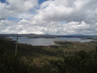
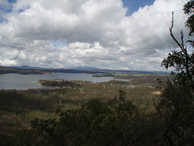
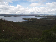
Lake Tinaroo is a popular tourist destination and recreational facility for the Atherton Tablelands.
Geographical
Tinaroo Falls Dam is situated on the Barron River, 12 kilometres by road from Atherton and 37 kilometres from Mareeba.
The Barron River and its tributaries drain an area of 1 900 square kilometres of the Atherton Tablelands into the Coral Sea near Cairns.
The total length of the river from its source to the sea is 166 kilometres.
The catchment area for Tinaroo Falls Dam is 545 square kilometres and the average annual rainfall is 1 300 millimetres.
Historical
White settlement on the Tableland dates back to the years immediately following explorer James Mulligan's discovery of the area in 1875. Indeed Mulligan rode along the Barron River past the present site of Mareeba to a point not far below Tinaroo Falls, before returning to Palmerville via the Atherton Scrub and Herberton Range.
In 1877 John Atherton took up "Emerald End" to become the first settler in the Barron Valley and many of the names he bestowed on the landscape remain today, including Tinaroo.
The discovery of the Hodgkinson Goldfield and tin in the Wild River brought improved access to the coast and a ready market for farm produce. Early farming concentrated on vegetables, corn, fruit and cattle.
The first successful experiments with tobacco growing were in 1928. In 1930 the Queensland Government threw open large areas of Mareeba-Dimbulah land for selection.
After a decade of set-backs it became clear that irrigation was the key to successful tobacco cultivation. Eight weirs had been built on local streams permitting limited irrigation development in areas adjacent to these storages but it was obvious that if increased supplies of water could be made available to the region, a considerable expansion of an already established industry could be obtained.
At the same time investigations began into increasing the generating capacity of the Barron Falls Power Station in order to utilise the full potential of the river and meet the increasing demand for power in North Queensland. It became clear that this could not be done without a storage on the river to even out seasonal flow variations.
In 1952 the decision was taken to build the Tinaroo Falls Dam and construction of the Mareeba-Dimbulah Irrigation Scheme was approved.
Construction of the dam for the State Government began in 1953 and was completed in 1958 at a cost of $12,666, 000.
Construction of the channel works to serve the Mareeba-Dimbulah Irrigation Area began in 1955 and was essentially completed by 1970. Minor extensions have since been made and these are continuing today.
Description
Tinaroo Falls Dam is a mass concrete gravity structure located on the Barron River above a series of rapids known locally as "Tinaroo Falls" and about 100 kilometres upstream of where the river discharges into the Coral Sea near Cairns.
The top of the dam wall is 45.1 metres above the river bed and has a central ogee crest spillway 76.2 metres wide and 3.7 metres deep to pass flood waters downstream. Two 1 500 millimetre diameter conduits through the dam wall discharge water to the irrigation channel and an additional 1 500 millimetre diameter cone valve allows water to be released to the river.
A subsidiary earth and rock filled embankment 6.4 metres at its highest point, 250 metres long, and containing some 23 000 cubic metres of fill was built across a saddle about a kilometre south of the main dam wall to prevent water escaping through this saddle during flooding. The road into Tinaroo township runs along the top of this embankment wall.
The capacity of the storage is 407 000 megalitres, which under normal conditions of operation is approximately two years supply. Water is stored in the reservoir during the annual late summer wet season and is then available during the dry months for irrigation, power generation and urban use. The storage first filled on the 31 March, 1963. Since then the maximum depth of water recorded through the spillway has been 2.32 metres on 13 February 1999.
Technical Specifications
- Catchment area: 545 square kilometres
- Average annual rainfall: 1 300 millimetres
- Storage capacity: 407 000 megalitres
- Annual yield for irrigation: 205 000 megalitres
- Assured yield for power generation: 72 000 megalitres
- Reservoir area: 3 360 hectares
- Full supply level: 670 metres above sea level
- Length of storage: 1 5 kilometres
- Length of shoreline: 209 kilometres
- Type of structure: Mass concrete gravity dam
- Height of wall: 45.1 metres
- Maximum base width: 35.4 metres
- Total crest length: 533.4 metres
- Quantity of concrete: 223 000 cubic metres
- Quantity of rock removed for foundations: 153 000 cubic metres
- Spillway type: Ungated, central ogee spillway
- Spillway dimensions: 76.2 metres x 3.7 metres
- Flood inflow (maximum): 256 000 megalitres/day
- Spillway discharge (maximum): 106 000 megalitres/day
- Irrigation outlets: 2 x 1 500 millimetre Radial Gates
- Barron River outlet: 1 x 1 500 millimetre Cone Valve
- Period of construction: 1953 -1958
- Cost: $12 600 000
Use of water
Irrigation
An assured annual supply of 205 000 megalitres is available for irrigation.
Power generation
A guaranteed minimum continuous flow of 197 megalitres a day or 72 000 megalitres a year is available to the Barron Gorge Hydro Electric Power Station. Under normal operating conditions much greater flows are available.
A Hydro turbine was installed at the dam wall in 2004.
Town water supplies
The townships of Tinaroo, Walkamin, Mareeba, Kuranda, Mutchilba, Dimbulah and Yungaburra are supplied from Tinaroo Dam.
Stock and domestic supplies
Water for stock and domestic purposes is supplied to approximately 500 properties throughout the Irrigation Area.
Flood mitigation
Although not designed as a flood mitigation scheme, the flood storage available in the dam at the start of the wet season can be a significant factor in reducing flooding in the Barron Delta. This was demonstrated during the cyclone of March 1967, when in one day 432 millimetres of flood rain fell in the dam catchment. The storage level was low and no water was passed downstream for four days, considerably reducing the flooding in the Delta during that critical period.
Tourism and recreation
Set on the Atherton Tablelands, against the Tinaroo Range and the Danbulla State Forest, Lake Tinaroo provides a popular tourist attraction and recreation facility.
The Queensland Water Resources Commission has made land available in Tinaroo Township, and the Eacham Shire at the southern end of the lake, for the development of tourist facilities. In both locations motels, restaurants, caravan parks, kiosks and picnic areas are available and recreational activities such as swimming, sailing, windsurfing, water skiing, fishing and canoeing are well catered for. Water-ski activities and a sailing club operate on the dam and concrete boat ramps are available.
Various community organisations such as the Queensland Recreation Council, The Scout Association of Australia and local churches maintain centres for young people around the lake foreshore.
The Forestry Department has provided lakeside picnic and camping facilities at Platypus, Downfall Creek, Kauri Creek, School Point and Fong-On Bay within the State Forest.
The Department of Natural Resources has stocked the waters of the lake with Barramundi, Silver Perch and Sooty Grunter from the fish hatchery at their Walkamin Research Station. These fish supplement the native sporting fish in the lake which are mainly Rifle Fish and Sleepy Cod.
An estimated 500 000 people visit Lake Tinaroo annually.
Mareeba-Dimbulah irrigation area
Description
The Mareeba-Dimbulah Irrigation Area covers an area of approximately 1175 square kilometres spread across the valleys of the Barron, Walsh and Mitchell Rivers at the northern end of the Atherton Tableland.
These lands are served by water from the Tinaroo Falls Dam in addition to the natural flows in the streams of the area. Additional supplies are provided to the Mutchilba and Dimbulah areas from Collins Weir on the Walsh River.
Approximately 205 000 megalitres are available annually for irrigation use, on the 41 500 hectares of farmland served. Water is made available to the farmers by gravity or pumping from the channel system or by private diversion from streams supplemented with water from Tinaroo Falls Dam.
A distinctive feature of the scheme is the diversion of water from Tinaroo Falls Dam on the eastward flowing Barron River across a saddle in the Great Dividing Range to serve lands in the catchments of the Walsh and Mitchell Rivers which flow to the Gulf of Carpentaria.
The soils and climate of the area have proven suitable for high quality production of a wide range of crops.
The soils vary from highly productive basaltic clay loams south and east of Mareeba, to more specialised sands and sandy loams of the granitic or metamorphic origin to the west of the town. Alluvial deposits border all the major streams in the area, while the heavy clays of the Arriga flats are ideal for rice production.
The climate is that of the tropical east coast, modified by altitude and the surrounding ranges. The irrigation area varies in elevation from 400 to 600 metres above sea level, hence the summers are warm, thundery and subject to monsoonal influences, while the winters are mild. Frosts, hail and cyclonic winds are unusual. Average maximum and minimum temperatures for Mareeba in January are 34 degrees C and 20 degrees C and in July 25 degrees C and 10 degrees C. Rainfall varies across the area from 1 300 mm near the coastal ranges down to 660 mm in the west.
Water distribution
Water from Tinaroo Falls Dam is distributed by gravity through 176 km of main channel to the various sections of the project, namely Walkamin to the south of Mareeba, East Barron and the Mareeba area itself, Paddy's Green and Arriga to the west of the town, and along the south bank of the Walsh River through Mutchilba to beyond Dimbulah. Within these sections a further 174 km of subsidiary channels distribute water to farms, dwellings and townships. Three major balancing storages at Nardello's Lagoon, East Barron and Arriga ensure that supply levels are maintained throughout the system.
In general, the main channels are either open earth or concrete lined. Short lengths of concrete lined steel pipe, reinforced concrete branch flume and cast in-situ concrete syphon have been used where the terrain and soil type required them. The lateral channels are in the main concrete or asbestos cement pipe.
The capacity of the main channel leaving Tinaroo Falls Dam is 19.8 cubic metres/second or 1 710 megalitres/day.
Relift areas
Two additional areas of good quality tobacco soils at Paddys Green (1142 ha) and Price Creek (704 ha) are served by four Commission owned pump stations which lift water to concrete balancing storages for further reticulation.
Supplemented streams
Water has also been made available for private pumping for irrigation purposes from streams supplemented with water from the channel system. In this way the extent of the channel system has been reduced and better use made of natural supplies available from such streams.
Releases are made to 15 individual tributaries of the Barron, Walsh and Mitchell Rivers to serve a further 5 530 ha of irrigable soil. In total, water is available for diversion from 276 km of supplemented streams.
Irrigation farms
In establishing the scheme, where vacant crown lands were available or existing farms were large, the land was acquired by the Commission and the subdivision redesigned to suit the proposed farm use and conform to the channel layout and drainage pattern of the area. In this way 193 new farms were created.
These new tobacco farms were designed with a minimum area of 40 ha containing at least 32 ha of soil suitable for tobacco, while those for irrigated pastures or rice have at least 200 ha of irrigable soils, 100 ha of which is sufficiently flat for rice production.
Little re-subdivision was carried out in areas served by water from the supplemented streams. Being near natural supplies, these areas had been closely settled for some time and no adjacent vacant Crown land was available. These small farms in the Mareeba, Walkamin and East Barron areas are now largely used for vegetable and horticultural production.
Today there are 402 farms supplied from the channel system, and 395 farms irrigated by private pumping from the supplemented streams. The total area irrigated annually is about 9 000 ha from a gross area of 19 206 ha of irrigable soil included in the farms. Water is allocated to each farm according to the crop grown and the area of irrigable soil as follows: tobacco 2ML/ha, pasture and horticultural crops 4ML/ha and rice 6ML/ha.
Normal area practice is to irrigate tobacco crops using semi permanent solid set sprinklers supplied on a roster system from the channel through on-farm storages or by direct pumping from the streams. Tree and vegetable crops are also spray irrigated, with trickle and mini-sprinkler systems being applied to larger orchards. Rice and pastures are watered by conventional flood irrigation methods, and 40 km of drains have been constructed by the Commission to take runoff water from these farms.
Crops
Tobacco has always been the major crop grown in the area. However with the downturn in the Tobacco Industry, Sugar Cane is now grown on the Tablelands in large quantities. Sugar requires a very large amount of irrigation which has put extra demands on the available supplies of water from Lake Tinaroo.
Peanuts, maize, sorghum, navy beans, melons, pumpkins and vegetables are grown. Plantations of avocado, macadamia, lychee, mango, citrus and other fruits have also been established. The area is recognised as the most suitable in Australia for coffee growing and four plantations have been established with the first harvest undertake in 1984.
Over the last decade long grained rice has become a major crop. Rice production is centred on the Arriga flats and Biboohra areas where channel extensions are underway to further expand the industry. Both summer and winter crops are grown and the product is railed to Ayr for processing.
Tropical grasses and legumes for seed production are cultivated while beef cattle fattening and stud breeding on irrigated pastures are continuing enterprises.
For the financial year 1983/84 the total value of production from the Irrigation Area was $46 889 652.
Barron Gorge power station
On its way to the sea, the Barron River falls more than 280 metres to the coastal plain. Engineering investigations into use of the river water for electricity generation began in 1906, but it was 1935 before the first turbine was driven by the waters of the Barron. The small Barron Falls hydro-electric station of 3.8 MW capacity, commissioned in that year, was the first underground power station in Australia. Before its closure in 1963, it had supplied the Cairns area with electricity for 28 years. However, this station used only a part of the water power available from the river and the remainder provided a ready source for use in the development of additional generating capacity, as power demands rose.
Before the potential of the river could be realised fully, a storage dam had to be built to even out the seasonal variations of flow. In 1958, the Tinaroo Falls Dam was completed and the Irrigation and Water Supply Commission of Queensland agreed to release some of the stored water for power generation while its irrigation scheme was being developed.
This compromise between the interests of power development and those of agriculture made possible the construction of the present Barron Gorge Hydro-Electric Power Station which began in 1960, with the Co-ordinator General's Department as the constructing authority for the Cairns Regional Electricity Board. The two 30MW machines were commissioned in 1963 and the station is now a vital unit in the State-wide generation and transmission system operated by the Queensland Electricity Generating Board.
Tinaroo Hydro power station
The Tinaroo hydro power station has been designed to take advantage of water being released for irrigation and other purposes from Tinaroo Falls Dam, as well as spillway discharges when the dam is full.
Water normally sent down the river or main channel is instead redirected via a diversionary pipeline through the hydro power station 's turbine before being redirected back into the channel or river.
The power station generates sufficient electricity into the State power grid to power homes and reduce Carbon Dioxide emissions by 8450 tonnes per year. This equates to taking nearly 2000 cars off the road for each year of operation. The hydro power station was commissioned in May 2004.
The Information on this page was obtained from "Tinaroo Falls Dam - Water for the Tablelands" - a booklet produced by the 'Queensland Water Resources Commission'.